
A New Tool in Environmental Risk Research
by Kevin Grover & ERIS staff
The environmental risk assessment business changes constantly, and sometimes the changes include new technologies that are real game changers.
Drones are such a technology. Outfitted with cameras and an increasing variety of multi-spectral sensors, drones offer environmental consultants a fresh option for gathering onsite property data.
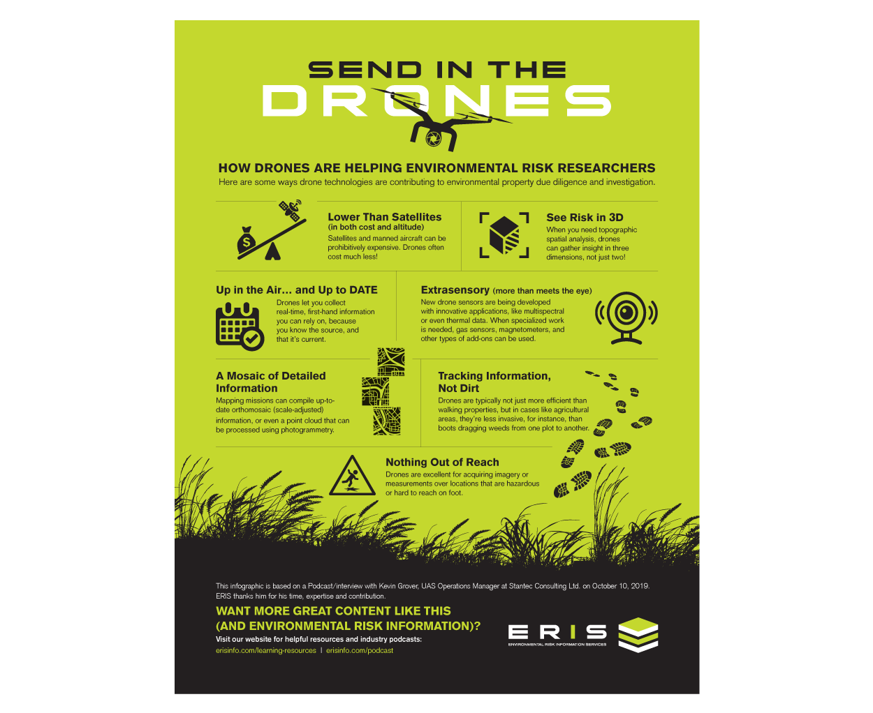
Compared to “boots on the ground” a drone in the air can add a 3D perspective to your field data collection, allowing you to see objects and patterns that may be hidden at eye level. Plus, sensor-equipped drones can enable you to detect images and details beyond the ordinary light spectrum.
Before you jump in with both feet (or propellers), note that it’s still early days, and you must consider important issues like safety and regulations. Let’s consider what you need to know about drones and their role in environmental research.
New Kid On (and Above) the Block
Let’s start with the obvious. Getting up in the air lets you see things you can’t easily (or in some cases, possibly) see by just walking around.
From ground level you can only see what’s open and visible (what’s on the horizontal plain or in front of you). With a drone you can conduct orthomosaic (scale adjusted) mapping missions; a detailed overhead perspective can reveal objects, patterns, and features only visible from above.
Cost Savings vs Satellites
Cost savings are certainly one of the drivers of interest in drones. Until recently, when companies needed overhead views and analysis of properties, they were limited to satellite imagery or photos taken by manned aircraft (which doesn’t come cheap). Custom data from these sources can be costly — often prohibitively so.
With drones, even the smaller professional ones (that retail for around $1,000) can have high-end video cameras, such that high-resolution imagery can be recorded at budget prices.
- STAY CONNECTED
Subscribe
Talk to us about how ERIS' constant innovations are making property due diligence easier and more efficient
Gather Data Quickly — from Exact Locations
For small-scale sites or properties with unique requirements, drones can collect large amounts of data quickly, and for a modest price. You can take the data back to the office for analysis.
A custom drone inspection also gives you the ability, while still onsite, to fly around and focus in on any features you want without obstacles. In dangerous environments, risk of injury is eliminated. Drones are less invasive than “boots on the ground” research. And safer.
In rural applications like farm fields or reclamation projects, ground-level investigation risks dragging weeds or other contaminants into the study area. Flying a drone instead lets you stay on the roadway. You can collect data while never actually stepping onto the property.
New Sensors for Expanded Data Collection Power
Sensors dramatically expand the information drones can collect, letting you see things that aren’t visible to the naked eye.
Multispectral data can be collected and analyzed back at the office. Gas sensors, magnetometers, and other types of specialized data collection tools are being used with promising results. Drones can detect thermal patterns or leaks from groundwater or other sources of seepage into the ground.
New sensors are introduced to the market all the time. Experts say the real promise of drones in environmental field work lies with these new sensors and specialized cameras.
Unlike cataloged data, you can be sure your custom drone data is up to date, and that it focusses on the specific features of interest. Drones let you collect precisely the kind of information you want, from wherever you want, without obstacle.
- ERIS’ RISK-E BUSINESS Podcast!
Click here to listen to the “Send in the Drones" Podcast with Kevin Grover, Stantec Consulting.


Regulatory Situation
While this work with drones is promising, it’s still all very new.
Several companies that use drones for environmental field research are currently working with regulators to verify the effectiveness of drone technology and its potential to replace other data collection methods.
Projects are underway to collect large volumes of data from scouting projects. These include data-defined archeological features (such as stone circles and other land features) that are best viewed from the air. The efficacy of the technology is still being established, and the regulations are still being written.
Safety Concerns
Drones may seem like fun, but the situation can become serious quickly when a drone crashes, causes damage, or flies into prohibited territory. It’s crucial to fly drones safely and legally. As best practices are developed for safe drone usage, we can expect better guidance and information for data collection workflows.
Be cautioned that — as with most new technologies — there are good vendors as well as fly-by-night salespeople (pun intended). And having the ability to operate a drone doesn’t make you an expert in environmental data collection, or even a professional drone operator. Vendors need to be up to date with new rules and regulations. (Education campaigns are already underway to help.) Because the barrier to entry is low, companies need to carefully investigate drone operators before hiring them, and ask for references.
Fly safe and know the regulations within the area you’re scoping.
This article was written by ERIS staff and is based on a podcast interview with Kevin Grover, UAS Operations Manager at Stantec Consulting Ltd. ERIS thanks him for his time, expertise and contribution. To hear our podcast with Kevin Grover, click here. And check out the Infographic and Fast facts that accompanies this article.
About ERIS
At ERIS, we know environmental risk data and research solutions. ERIS is a leading provider of environmental risk information for properties in Canada, the United States, and Mexico. Our depth and variety of data, coupled with our innovative tools like ERIS XPLORER, make Phase I ESAs and environmental due diligence easier than ever. For the best in Phase I research, CONTACT one of our knowledgeable Regional Account Managers, or VISIT ERISinfo.com.