PRODUCTS & SERVICES
Database Reports
Standard delivery time for all ERIS reports is 3 business days unless otherwise specified below.
NEW: All database reports now include ERIS Xplorer.
Rush service is available at an additional charge: 1 business day + $150.
All prices in CAD as of April 2, 2022.
- STANDARD
- STANDARD EXPRESS
- STANDARD SELECT
- SITE REPORT
- CUSTOM
- ON WASTE DISPOSAL
- ON RSC
- ON RSC PKG
- ON AERIAL PKG
- BC PREMIUM
- BC SITE
- BC PREM EXPRESS PKG
- BC SITE EXPRESS PKG
- ALBERTA STANDARD
- QUEBEC RRE
- NEW BRUNSWICK STANDARD
- CLIMATE RISK ASSESSMENT
- EXTRAS
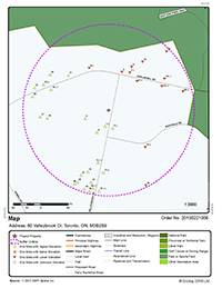
Standard Report $385
- Information for subject property and adjacent properties within 250m radius
- All federal, provincial and private source databases
- Accurate and detailed reports
- Overview and detailed street maps with point data
- Interactive display of precise information through links between summary and detailed information
- Bookmarking between pages for ease of use
- Scrubbed and cleaned data, with low orphan sites
- Easy-to-read format
- Satisfies the “site and adjacent properties” obligation of CSA Standard Z768-01
If 250m is not a sufficient search radius, a Custom report may be required.

Standard Express Report $405
A standard report delivered fast, within minutes of placing an order, and not verified by a report analyst.
Standard Select Report $280
- Environmental data for the site and adjacent properties within 250m radius
- Limited to any 8 federal, provincial or private databases as chosen by the client
If a 250m radius is not sufficient, a Custom report may be required.
Site Report $155
- For the subject site only; no adjacent property information is provided
- Includes a search of all federal, provincial and private source databases
- Delivery timeline for this report is the next business day
For larger sites that do not fit within the standard 250m radius, a CUSTOM report will be required. The delivery timeline for this report is the next business day.
Custom-Build Your Own Report Type Contact ERIS Sales
While the report types listed above have a set 250m radius and a set number of databases searched, ERIS also offers clients the flexibility to build their own reports. Clients choose the search area, radius/buffer, and the number of databases to be searched for their project. Custom reports are generally required for large or irregularly shaped sites, pipelines, road/transit corridors, watersheds, new developments, golf courses, agricultural lots, and large industrial sites. Once the project requirements are determined, the client will be provided with a custom quote.
A quotation may take 1–2 business days, and a $25 quote fee will be applied if the report is not purchased.
Waste Disposal Site Report $195
This Report searches on Waste disposal grounds located within a 500m radius of a subject site.
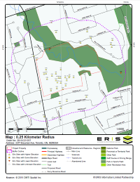
RSC Report (Record of Site Condition - RSC-ON) Urban $805, Rural $505
The new RSC (Record of Site Condition) Report was designed to meet the requirements of the amended Brownfield Regulation 511/09. This report includes a search of all Ontario databases (federal, provincial and private) within a 300m buffer from the property boundaries of a subject site located within an urban or rural area. Also included in the report are 6 reference maps with their accompanying reports and metadata. The 6 maps are comprised of an ANSI (Area of Natural and Scientific Interest) map, a Bedrock Geology and Surficial Geology map, a Physiography map, an Ontario Base Map (OBM) and a Soil map. All maps conveniently locate your subject property as the centre point of a 2000m radius. The map legends and supplementary reports provide all the specifics needed to interpret the maps.
For properties over 7 acres or corridors over 500m in length, select the RSC Report Quote option.
RSC Package (Record of Site Condition - RSC-ON) Urban $975, Rural $675
Includes an RSC (Record of Site Condition) Report plus Decade Aerials and PSR (Physical Setting Report), delivered through Xplorer.
For properties over 7 acres or corridors over 500m in length, select the RSC Report Quote option.
Ontario Aerial Package $600
This package will include: a Standard Database Report, georeferenced Historical Aerials*, an Ontario Base Map (OBM) – all delivered and presented through ERIS Xplorer
- Xplorer saves you time and money by creating a more streamlined and efficient review and analysis process. Review your environmental data and layer your historical aerials on one central platform.
*The ERIS Team will select the best aerial for your site from each decade (if available) with regards to coverage, scale and quality.
BC Site Registry Report $260
A search of BC’s Site Registry is a requirement of any Stage 1 Preliminary Site Investigation (PSI) in British Columbia. ERIS’ BC Site Registry Report provides clients all of the Detail Reports for each specific record found in the Site Registry up to 500m.
BC Premium Express Package $455
This package includes an ERIS Database Report to 250m, BC Site Registry Report data to 500m, a Topographic Map and Xplorer, all delivered in minutes. 'Delivered in minutes' because the report has not been reviewed manually by an internal report analyst.
BC Site Registry Express Package $200
This package includes BC Site Registry data to 500m, a Topographic Map, and Xplorer, all delivered in minutes. 'Delivered in minutes' because the report has not been reviewed manually by an internal report analyst.
Alberta Standard Report Plus $470
Designed to meet the revised Alberta Environmental Site Assessment regulations, as of March 1, 2016. The report searches all Alberta databases (federal, provincial and private) within a 300-metre buffer from the property boundaries of the subject site.
Please note for properties over 7 acres or corridors over 500 metres in length, a custom quote/report is required. For more information, please contact your ERIS sales representative.
Quebec Environmental Risk Report (RRE) $205
Designed specifically to meet the needs of our Quebec clientele, the RRE report searches the top 5 most consulted provincial databases from Quebec for a subject site and adjacent properties. Databases include: Contaminated Sites, Authorized Waste Disposal Sites, Hazardous Waste Disposal Sites, Petroleum Equipment Usage Permits and Water Wells. By allowing ERIS to do all the preliminary research, consultants save time and money.
The report is delivered within 4 business days.
New Brunswick Standard Report $280 Standard Select Report $385
Within the province of New Brunswick, a search for Property Based Environmental Information (PBEI) is an essential requirement when conducting Phase 1 ESAs. In an effort to continually provide high quality service and reports to our clients and enhance our one-stop-shop service, ERIS now includes the Property Based Environmental Information for a subject site under investigation on all New Brunswick Standard and Standard Select reports at no extra charge! ERIS Standard and Standard Select reports include a search of federal, provincial and/or private source databases for a subject site and adjacent properties within a 250m radius.
Include New Brunswick PBEI at no extra charge!
Climate Risk Assessment $195 per report
ERIS is proud to partner with ClimateCheck® to help the Canadian environmental due diligence industry assess the increasing risks to property due to the changing climate. ERIS now offers reports to enable every real estate stakeholder to instantly understand the climate risks for their properties.
ClimateCheck® distills the best and latest climate change research into a hyper-localized assessment of an individual property’s vulnerability to every risk, assessing five types of hazards:
- Precipitation: Risk of precipitation
- Drought: Risk of water scarcity
- Heat: Risk of extreme heat
- Fire: Risk of wildfire
- Flood: Risk of inland flooding
Sites up to 160 acres. Larger sites will receive a quote.
Excel Add-On $28 plus
An Excel Add-On is an optional file you can order with your ERIS Report. They allow you the convenience of integrating database hits from your ERIS Report into your GIS platform and/or report and overlay it with other information pertaining to your project. Once your ERIS Report is complete you will receive an Excel file with the database hits within the search radius. The table will include the following fields: Database Source, Map Key, Company Name, Address, City, Postal Code, X Coordinate, and Y Coordinate.
Excel Add-Ons are available for all ERIS Report Types at an additional cost:
- Standard/Standard Select Reports $28 extra
- For all other reports a Quote will be provided
Project Boundary File $12
Project Boundary file (KML File format) – Available immediately
HISTORICAL PRODUCTS, DIGITAL TOOLS & APPLICATIONS
- FIRE INSURANCE MAPS
- TOPOGRAPHIC MAPS
- NEW INFO! CITY DIRECTORIES
- HISTORICAL AERIALS
- LAND TITLES
- INSPECTION REPORTS
- SITE PLANS
- NB PBEI
- AB ENFORCEMENT SEARCH
- PHYSICAL SETTING REPORT (PSR)
- ERIS XPLORER TOOL
- ERIS MOBILE APP
- FIGURE CREATOR
- ERIS DIRECT
- SCRIVA
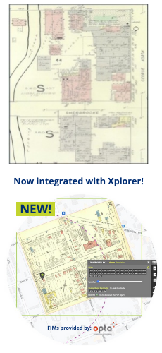
Fire Insurance Maps
Fire Insurance Maps display streets and buildings of urban Canada in great detail. These maps illustrate building construction, occupancy and potential fire hazards tracing the historical development and providing detailed information of storage tanks, transformers, boilers and electrical rooms.
The original maps were produced between 1875 and 1923 and updated until production ceased in 1974. There may be multiple maps available for the same location in some instances. The original fire insurance maps were produced by Chas. E. Goad Co. between 1875 and 1923.
Fire insurance maps can be overlaid with ERIS’ data points, and the other map layers ordered, to easily detect and distinguish building and land use changes.
| Format | Standard Delivery | Cost | Research Fee |
|---|---|---|---|
| electronic | 2-5 business days | ON $110; All other provinces $125, per coverage year by volume | $50 |
The research fee is applied once per address searched and applies to a full search for FIMs, Inspection Reports and Site Plans.
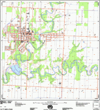
Topographic Maps
ERIS offers digital topographic maps for all of Canada. Maps are available at a scale of 1:50 000 and delivered within 3 business days. The maps include airports, buildings, contour lines, spot heights (elevations), hydrography, lakes, watercourses, hypsography, drainage, municipal boundaries, parks, pits and quarries, roads/streets, railways, utility lines, vegetation, wetlands, native reserves and the township boundaries as originally surveyed by the Crown.
In Ontario, digital Base Maps are provided at a scale of 1:22 000.
| Standard Delivery | Cost | |
|---|---|---|
| All provinces and territories | 2-5 business days | $25 |
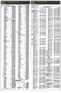
City Directories
The ERIS City Directory Search provides detailed historic property-use information for the site property and surrounding area with nationwide coverage with information dating back to the late 1800's.
A city directory search is part of the mandatory records review section of the Canadian Standards Association (CSA) Z768 Phase I Environmental Site Assessment. Relevant information is researched for the site and surrounding properties in five-year intervals. All information is researched at the Library and Archives Canada in Ottawa.
| Format | Standard Delivery | Rush Delivery |
|---|---|---|
| electronic image | Contact Inside Sales and Support | +$60 RUSH DELIVERY |
| No Records Found | $25 |
|---|---|
| cd Subject Site only | $90 (3-5 business days) |
| NEW! SMARTCD (SUBJECT PROPERTY & ADJACENTS) | $195 (5 business days) |
| Custom SEARCH | Quote (turnaround time & cost) |
In certain situations, we recognize the need for a radius or site plus 5/10 street CD search. To ensure optimal service, these will be custom quoted with project-specific turnaround times and costs.

ERIS' SmartCD – NOW AVAILABLE
SmartCD uses the expertise of our seasoned city directory researchers, who understand the historical and regional nuances that make each city unique. Traditionally, city directory searches have been focused on the site or within a certain radius. However, this approach can yield hundreds of pages of results, leading to a lengthy and costly report that takes an excessive amount of time to complete. Hence, we've developed the SmartCD, a tool that streamlines this process, delivers only the data that you need, and meets or exceeds the CSA Z768-01 standard for Phase I ESAs.
SmartCD simplifies the research process in three easy steps:
- Choose your Phase I Property when placing the order – no need to provide street names or address ranges.
- Our expert team pulls relevant adjoining property addresses based on your subject property boundaries, utilizing property information, historical maps, imagery, and other reliable sources.
- Enjoy the convenience of a scanned high-quality image of the directory provided in pdf output. The SmartCD brings the library to you, delivering accurate results without the risk of transcription errors. Image reports offer valuable context, including cross streets and added comments for identifying other features or nearby properties of interest.
Experience the smartest way to conduct city directory research. Click here to learn more about its powerful capabilities.
Our Regional Account Managers are available to provide personalized guidance and demonstrate how the SmartCD innovation can streamline your ESA process. You can reach out to your Regional Account Manager directly or contact us via email at [email protected].
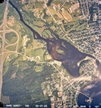
Historical Aerial Photographs
Aerials from ERIS' National Collection can be acquired for decades from 1920 to 2010. You select the decades for which you want to receive aerials and the ERIS Team will select based on the best coverage, quality and scale. An aerial selection list will no longer be provided. The final delivery will be in a geo-enabled .pdf with metadata for each aerial. Aerials can also be accessed, layered and analyzed through ERIS Xplorer (which is included with the purchase of any database report, or can be added to a purchase of aerials for an additional $40).
| All Provinces and Territories | ||
| Cost | $32 each | |
|---|---|---|
| Scale | 1:5000 to 1:50000 | |
| Format | Standard Delivery |
|---|---|
| GEO-ENABLED PDF | 4-5 business days |
For more information, visit: https://www.erisinfo.com/ca/historical-aerial-photographs/
Land Titles
Land Titles contain legal title information concerning property ownership, transfer details and any encumbrances such as mortgages or easements.
Each time a new transaction occurs, property records are updated as soon as the instrument is registered. The information contained within a land title search does differ based on the province or territory. If a title search is requested for sites in provinces other than Ontario, clients will be contacted to confirm cost estimates and search requirements. Where available, registered property plans can also be ordered.
| Cost | Format | Research Fee | Standard Delivery | ||
|---|---|---|---|---|---|
| British Columbia | Land Title | $45+ | electronic | 3–10 business days | |
| Historical Title | $100+ | $40 | 7+ business days | ||
| Alberta | Land Title | $35+ | electronic | 3–10 business days | |
| Historical Title | $100+ | $40 | 7+ business days | ||
| Saskatchewan/Territories | Land Title | $35+ | electronic | 3–10 business days | |
| Historical Title | $35+ | $40 | 7+ business days | ||
| Manitoba | Land Title | $45+ | electronic | 5–10 business days | |
| Historical Title | $140+ | $40 | 7+ business days | ||
| Ontario | Land Title | $60+ | electronic or hardcopy | 3–10 business days | |
| Historical Title | $100+ | $40 | 15+ business days | ||
| Quebec | Land Title | $100+ | electronic | 3–10 business days | |
| Historical Title | $100+ | $40 | 5 business days | ||
| Maritimes | Land Title | $100+ | electronic | 7–10 business days | |
| Historical Title | $125+ | $40 | 15+ business days |
Inspection Reports
Property Underwriters Reports provide detailed information on a site-specific basis. Reports include descriptions of building construction, heating sources, production processes, and the presence of any hazardous chemicals or materials which may be stored on site. They also indicate the presence of environmental hazards such as electrical rooms, transformers, boilers, and storage tanks.
| Format | Standard Delivery | Cost | Research Fee |
|---|---|---|---|
| electronic | 2-5 business days | $60 for each target address | $50 |
The research fee is applied once per address searched and applies to a full search for FIMs, Inspection Reports and Site Plans.
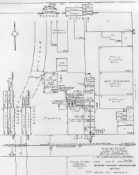
Site Plans
Property Underwriters Site Plans have been produced by the Insurers' Advisory Organization for the past 100 years. These individual design drawings and field surveys identify the location, capacity, and contents of above and below-ground storage tanks, chemical storage, and other forms of environmental hazards.
| Format | Standard Delivery | Cost | Research Fee |
|---|---|---|---|
| electronic | 2-5 business days | AS OF AUG 1/16: ON/QB* $70 each; Maritimes custom pricing; BC/Prairies n/a | $50 |
*Quebec: Large Site Plan min $75 / max $175
The research fee is applied once per address searched and applies to a full search for FIMs, Inspection Reports and Site Plans.
New Brunswick Property Based Environmental Information (PBEI)
Property Based Environmental Information searches are unique to the province of New Brunswick and is an essential part of any Phase 1 ESA being conducted within the province. ERIS includes a free search for PBEI for the subject property under review for any Standard and/or Standard Select report ordered for New Brunswick. Requests are processed through the New Brunswick Department of the Environment and include a comprehensive search of following databases: Ministerial Orders or Remediation Orders, Petroleum Storage Tanks, Remedial Activity or Contamination, PCB Storage Sites and Landfill Sites. Results can take between 3-5 days to be delivered by email. Original copies are then mailed.
AB Enforcement Search (Alberta Only)
To our valued clients in Alberta, and across Canada, who order data and information for Alberta,
ERIS has now added the Alberta enforcement search data to our Alberta database reports. The data comprises historical compliance enforcement records taken against a company or individual related to Alberta Environment and Parks’ current and past legislation; and includes details such as enforcement name, description, and last update.
For more information, please contact your local Regional Account Manager, and for Alberta, that is Mike Seifert, [email protected]
Physical Setting Report (PSR)
$80 with a Database Report; or as a bundle with ERIS Xplorer for $90 (without the purchase of a Standard Database Report). Ask us about PSR pricing for a custom report.
The ERIS PSR provides comprehensive information about the physical setting surrounding a site and includes a complete overview of topography as well as hydrologic, geologic and soil characteristics. The location and detailed attributes of oil and gas wells, water wells, public water systems and radon are also included for review. The PSR is also available for large/custom areas.
Report Components
- Current Topographic Map
- Shaded Relief Map with contour overlay and labels of elevation
- Attributes: Elevation, Slope Direction
- Hydrologic Information
- Wetland Map
- Provincial Significant Wetland (PSW) Map (NB and ON)
- Geologic Information
- Bedrock Geology Map
- Attributes: Bedrock Units, Primary/Secondary Rock Type, Geological Timescale, Strata, Lithology, Tectonic Zones, Geological Province
- Surficial Geology Map
- Attributes: Surficial Geology Units, Unit Description, Material, Texture, Age
- Bedrock Geology Map
- Soil Map
- Attributes: Soil Type, Stoniness, Soil Components, Steepness, Water Table Characteristics, Drainage, Soil Horizon Information (Depth, Surface Material, Deposition, Parent Material, Electrical Conductivity)
- Oil and Gas Wells
- Attributes: Well Type, License Information, Total Depth, Ground Elevation, Status, Operator and Drilling-Related Information)
- Water Wells and Groundwater Wells
- Attributes: Water Level, Depth to Bedrock, Depth to Water Table
- Radon Information
- Attributes: Low/Medium/High Risk at Target Property, Percentage of Homes Tested with Radon Concentrations Below 200 Bq/m3, Between 200 and 600 Bq/ m3, Above 600 Bq/ m3 for each Province and Territory
- Area of Natural and Scientific Interest (ANSI) Map (ON only)
- Attributes: ANSI Name, ID, Type, Significance, Management Plan, Area, Comments
The PSR can be added to your order of any Database Report for an additional $80 on the Order Form, or as a bundle with ERIS Xplorer for $90 with the purchase of a Standard Database Report; ask us about PSR pricing for a custom report.
For more information, visit: https://www.erisinfo.com/ca/now-available-physical-setting-report/

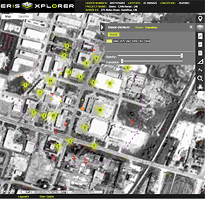
ERIS Xplorer
Now included with every database report
Xplorer is an add-on to ERIS products, including Database Reports, Topographic Maps, Aerials, the ON RSC Report, layers from the Physical Setting Report and Fire Insurance Maps and Inspection Reports (if ordered). Xplorer allows you to quickly visualize and analyze environmental risk information related to a particular location, with built-in tools for analysis and customization.
Features of ERIS Xplorer
- Overlay data and multiple images over current street layers.
- Switch between Street, Satellite, or Terrain base layers to more effectively analyze the project property and related data.
- Accommodate Custom/Linear Reports for efficient review and analysis.
- View the transition of Aerial images through the decades using the Transition Tool.
- Filter data sources and view only the desired data sources on the map.
- Look up specific addresses or keywords using the Search functionality.
- Calculate distance and area using the Measure Tool.
- Draw and/or add comments directly to any layer, then print to PDF for easy sharing between colleagues and clients.
- Save views with your drawings, measurements, notations, and filters.
Exciting New Feature!
- Digital fire insurance maps from OPTA Information Intelligence’s country-wide collection have been geo-referenced and adjusted to overlay onto current street layers within the ERIS Xplorer platform. ERIS’ customers can use this state-of-the-art visualization tool in real time – to identify, reveal and analyze important geographical artifacts and boundaries, including the placement of buildings, reservoirs and other features, as they evolved.
- Also available, Inspection Report locations are now identified on the map view, and the reports accessible for viewing or downloading simply by clicking the icon.
ERIS Xplorer is included with every database report. It can be added to any order of a topographic map, aerials, ON RSC, or the Physical Setting Report (PSR) for an additional $40 without the purchase of a database report. Ask us about Xplorer pricing for a custom report.
For more information, visit: https://www.erisinfo.com/ca/eris-xplorer/

ERIS MOBILE Field App Download for free and access your ERIS orders in the app
ERIS Mobile is the first-ever fully integrated mobile app for on-site environmental due diligence.
- View data and images for your project on an interactive map – from your device
- See your project details just like you would in the office
- Upload new information like photos and notes, and tag their exact location
- Complete on-site checklists
- Easily access all the information you collected in the field to use in Xplorer, Figure Creator and now, Scriva!

FIGURE CREATOR Access Figure Creator through ERIS Xplorer
- Prepare, crop, annotate, title, customize and save/generate the images you want.
- Zero in on the important features of your site that your client will want to see. Highlight just what you want to show. Create the perfect Figure 1.
- Customize any figure by adding data layers, boundaries, drawings/symbols and annotations – whatever you need to make the right things stand out. Add titles and comments to your photos.
- Seamlessly integrate the photos captured on-site via ERIS Mobile (or upload your own), so they become a key part of your appendix document.
- You can use any image from the project as a figure, such as FIMs, Aerials and Topos.
- Xplorer has several built-in templates that you can brand with your company logo and then incorporate your customized figures and photo logs.
ERIS DIRECT: On-Demand Information for Environmental Risk Searches
Does your company need regular access to environmental site information? Do you want answers immediately? ERIS DIRECT is for you.
Real Time Environmental Risk Information
ERIS DIRECT is an online subscription service that provides real-time environmental risk information for properties throughout the United States and Canada. Environmental risk searches can be performed from your own computer, on specific addresses and/or company names, with environmental information delivered to you immediately.
ERIS DIRECT lets you quickly assess property condition and environmental perils for:
- Environmental audits
- Site selection
- Financing
- Underwriting
- Financial reporting
- Legal due diligence
- Mergers & Acquisitions
- Divestitures
ERIS DIRECT features include the ability to:
- Search for data in both the US and Canada
- Save environmental search criteria and results
- Combine the results from many searches on one report
- Drill down to the information you need with Country, State/Prov and Data Source filters
- Easily review records in your searches and choose to include/exclude them from your report
- Choose the file format of the final output
- View the projects your staff are working on and see the status
- Make projects 'private' to ensure confidentiality or 'public' to facilitate collaboration across individuals and offices
Let ERIS DIRECT make your environmental risk searches easier — and faster. For more information, visit: www.erisinfo.com/ca/eris-direct/
Scriva
Scriva is the latest technology innovation from ERIS, completing a comprehensive array of tools, including ERIS Xplorer, ERIS Mobile, Figure Creator, the Vapor Screening Tool (US), and ERIS Direct.
Scriva is a state-of-the-art online report-writing platform that offers:
- Flexible, form-built document templates
- Comprehensive integration with all ERIS data and tools
- Unlimited users and templates
- Easy-to-use, customizable interface and project management dashboard
For more information about everything Scriva can do to make report writing easier, visit scriva.com, or contact Melissa Perkins-Nelson, Solutions Account Manager (North America) at [email protected]
THE ERIS REPORT
ERIS database reports provide current and historical environmental information for any property in North America in a concise and comprehensive manner. Key federal, state or provincial and private sector databases are researched to identify and pinpoint environmental concerns associated with a particular property. ERIS reports are used to aid in the identification of possible environmental risks for commercial, industrial and residential sites. ERIS reports meet the CSA standards in Canada and the ASTM standards in the United States. Each report contains:
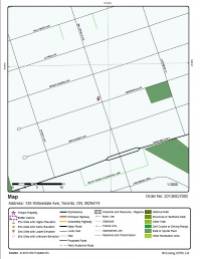
- A map that displays the subject property at the center of a predefined radius and all adjacent properties that lay there within.
- A current aerial that displays the subject property and surrounding areas.
- An executive summary that indicates site information such as site name, address, elevation, latitude/longitude.
- A report summary that shows databases that were researched and the number of points that lie within preset search distance for each database. (Clicking on the database abbreviation will take you to the database descriptions section).
- A site report summary that lists sites within the project property and surrounding properties and indicates distance and elevation difference; sites are sorted by distance and direction. (Clicking on the ‘map key’ will send you to the relevant map; clicking on the ‘page number’ will take you to that site’s detail in the detail report).
- A detail report of all the records found within the radius that surrounds the site; these records can be matched to locations on the site diagram by way of the ‘map keys’.
- An appendix that lists definitions and database descriptions.
NEED-TO-KNOW FACTS About the ERIS Report
Functions within the database report are best optimized with Adobe 11
- Interactive links are highlighted in blue
- Adobe Bookmarks are located on the top left-hand side of the report; click the second icon to reveal the green table of contents; click on a section to access the details within, as well as the blue interactive links
Over 10 Million Records
ERIS has collected over 10 million environmental and property-related records from various Provincial/Territorial, Federal and Private Sources to meet the needs of your property due diligence. Updates occur on a very frequent basis to ensure your reports include the most current information that is publicly available.