PRODUCTS & SERVICES
Database Reports
ERIS COVERS THE UNITED STATES!
Whether you are doing a Phase I, Phase II, remediation, loan or insurance assessment, or legal due diligence, ERIS is your fast, accurate and affordable resource for assessing environmental risk. ERIS can provide environmental database reports that meet ASTM/AAI standards, as well as the historical products of your choice to fulfill your requirements.
All prices in USD.
- ERIS DATABASE REPORT
- CUSTOM AREA/CORRIDOR REPORT
- REPORT PACKAGES
- ERIS NEPA REPORT
- CLIMATE RISK ASSESSMENT
- PHYSICAL SETTING REPORT
- PERMIT TIMELINE REPORT
Database Reports (includes Physical Setting Report - PSR) $145
Database Reports (no PSR) $95
ERIS database reports provide current and historical environmental information for any property in the United States in a concise and comprehensive manner. Key federal, state and private sector databases are researched to identify and pinpoint environmental concerns associated with a particular property.
- 1-3 day turnaround time
- Multiple Radius Database Report meeting ASTM standards
- ‘Express Preview Report’ is available within minutes of ordering
- Accurate and detailed environmental risk reports
- Precise property locations for more accurate risk assessments
- Overview and detailed street maps with point data
- Interactive display of precise information through links between summary and detailed information
- Bookmarking between pages for ease of use
- Scrubbed and cleaned data, with low orphan sites
- Easy-to-read format
ASTM/AAI-Standard Reports
All reports include customized and interactive maps of various scales, showing target properties and surrounding areas, as well as detailed records found within defined radii. All records are linked to the final detailed report. Key databases include:
- CERCLIS List
- CERLCIS NFRAP Site List
- Delisted NPL Site List
- ERNS List
- Federal Institutional and Engineering Control Registries
- FIND/FRS Site List
- MLTS Sites
- NPL Site List
- RCRA CORRACTS Facilities
- RCRA Generators List
- RCRA TSD Facilities
- Superfund Enterprise Management System (SEMS)
- Spill/Incident Reports
- State Brownfield Sites
- State Hazardous Waste Sites Identified for Investigation or Remediation
- State Institutional and Engineering Control Registries
- State Solid Waste Disposal Sites
- State/Tribal Leaking Storage Tanks
- State/Tribal Registered Storage Tanks
- State/Tribal Voluntary Cleanup Sites
- TRI List
- TSCA Sites
Custom Area/Corridor Report
Custom area radius reports allow you to conduct information gathering for environmental site assessments in a set radius around a site locus, or to define your own custom site boundaries. These reports are ideal for large or irregularly shaped sites.
Custom corridor reports are ideal for projects that follow a line such as railroads, pipelines, roads, and tracks – where search results can be tailored to a linear property boundary.
For either type of report, you choose the search area and the databases required (or search all). Our proprietary software combines environmental site data from several different databases including federal, state, and local governing environmental records to produce a thorough and detailed report. The report highlights environmental risk features from the storage of hazardous materials to sites with environmental liability or contamination issues.
Need a quote for a large, irregularly shaped site, or corridor search?
Select “Quote – Area/Corridor Custom Report” on the ‘Select Report’ page. A quotation is provided within 1 business day.
- Large areas – you can submit your custom boundaries by creating a specific polygon, or by uploading a site map.
- Corridor sites – you can submit the coordinates, a map, or even a site illustration by email. Our mapping professionals will create a custom report with the required defined distance around the corridor.
Report Analyst-verified, delivered in 2 business days after approval.
ASTM/AAI-Standard Reports
All reports include customized and interactive maps of various scales, showing target properties and surrounding areas, as well as detailed records found within defined radii. All records are linked to the final detailed report. Key databases include:
- CERCLIS List
- CERLCIS NFRAP Site List
- Delisted NPL Site List
- ERNS List
- Federal Institutional and Engineering Control Registries
- FIND/FRS Site List
- MLTS Sites
- NPL Site List
- RCRA CORRACTS Facilities
- RCRA Generators List
- RCRA TSD Facilities
- Superfund Enterprise Management System (SEMS)
- Spill/Incident Reports
- State Brownfield Sites
- State Hazardous Waste Sites Identified for Investigation or Remediation
- State Institutional and Engineering Control Registries
- State Solid Waste Disposal Sites
- State/Tribal Leaking Storage Tanks
- State/Tribal Registered Storage Tanks
- State/Tribal Voluntary Cleanup Sites
- TRI List
- TSCA Sites
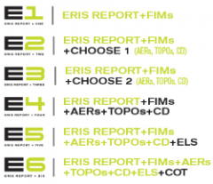
Environmental Database Report Packages
E1 $115/$180 E2 $230 E3 $295 E4 $330 E5 $430/$705 E6 $625/$880
ERIS introduces environmental database report product packages…
The foundation of each package is an ERIS Database Report for your site of choice.
- The E1* includes a corresponding set of Fire Insurance Maps from our comprehensive collection of Historical products.
- The E2 package adds a choice of one of three additional Historical products: Aerial Photos, Topographic Maps, or a City Directory (one street). The new Physical Setting Report (PSR) will be included in every E2 to E6 package. (Prices quoted reflect 'not finding' or 'finding' FIMs associated with the subject property).
- The E3 adds a choice of two of three additional Historical products to your environmental database report. Choose from: Aerial Photos, Topographic Maps, or a City Directory (one street).
- The E4 is an ERIS Database Report, plus FIMs, Aerial Photos, Topographic Maps and a City Directory (two streets).
- The E5 package adds an Environmental Lien Search to your Database Report and Historical information. Option to have ‘ELS – Current owner only’ or ‘ELS ASTM E1527-21 Compliant ELS – Ownership back to 1980’
- The E6 adds a Chain of Title to your Database Report and Historical information. Option to have ‘ELS – Current owner only’ or ‘ELS ASTM E1527-21 Compliant ELS – Ownership back to 1980’
ERIS Xplorer, our powerful visualization and analysis tool, will be included with every Database Report Package.
The offering of these product packages will not impact any current packages or volume pricing agreements previously established with ERIS.
*$115 without FIM coverage / $180 with FIMs; Option to add PSR $160 without FIMs / $180 with FIMs
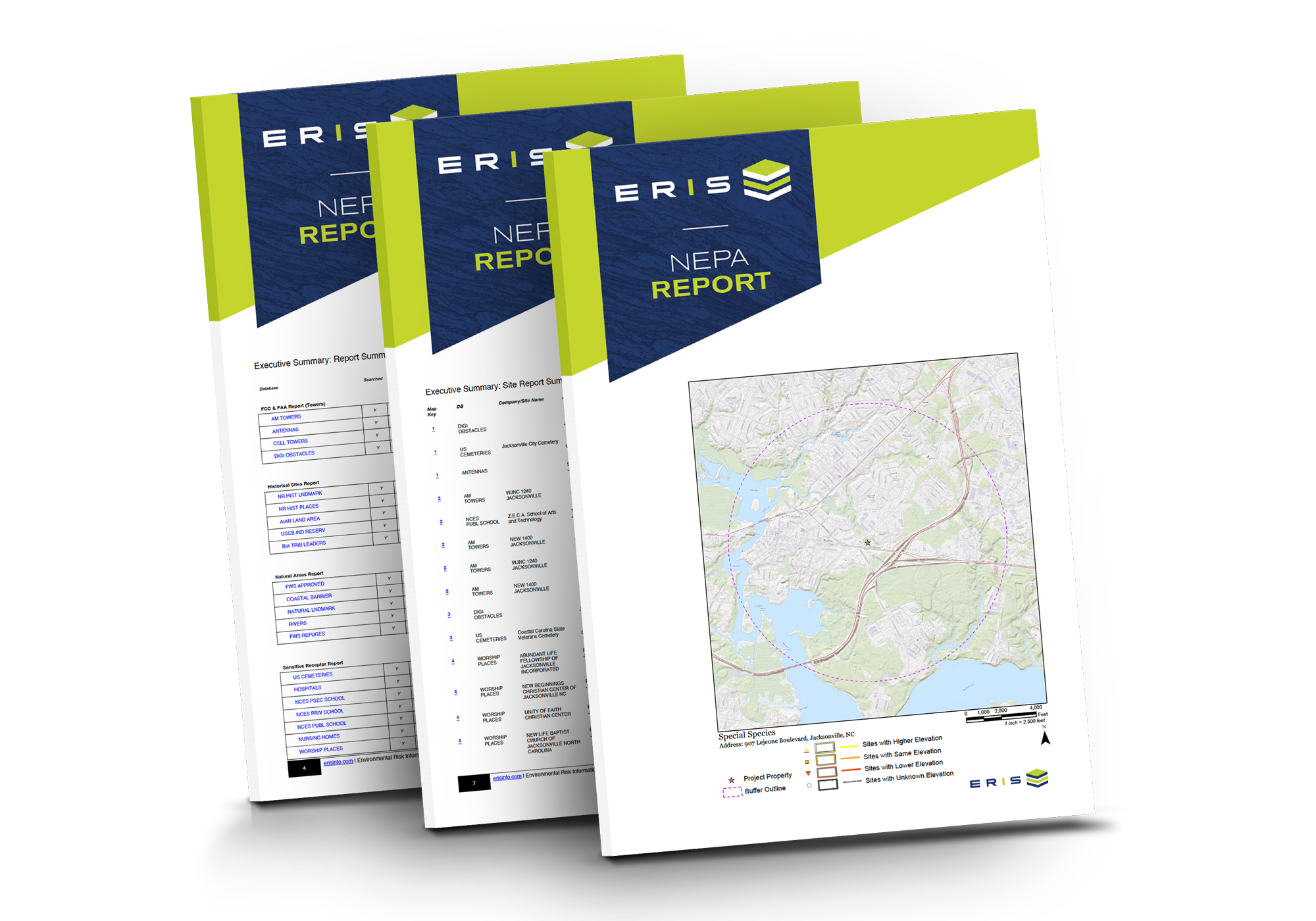
ERIS NEPA Report
ERIS NEPA Report is an invaluable first step in your impact analysis when your project requires compliance with NEPA. It identifies sensitive receptors critical to your analysis, including wildlife refuges, historical sites, natural areas, floodplains, and more.
New: The enhanced format and up-to-date information provided by the ERIS NEPA Report, combined with the integrated data and layering capabilities in Xplorer, completely transforms the NEPA assessment process.
The ERIS NEPA Report is delivered in PDF format to your My Orders Page and Xplorer under the 'Reports' tab. Additionally, the ERIS NEPA report is available in Scriva and can be added to the Appendix directly from the ERIS Order.
Cost: $135
Turnaround time: 2-4 business days
Special Status Species Report for Texas
ERIS also offers a Special Status Species Report for Texas. The report includes critical habitats, rare, threatened, and endangered species of Texas, TX Natural Diversity Database Element Occurrences, and wildlife-managed areas.
Cost: $85 plus
Turnaround time: 2-4 business days
Learn more: erisinfo.com/nepa-report
Climate Risk Assessment $135 per report
ERIS is proud to partner with ClimateCheck® to help the environmental due diligence industry assess the increasing risks to property due to the changing climate. ERIS now offers reports to enable every real estate stakeholder to instantly understand the climate risks for their properties.
ClimateCheck® distills the best and latest climate change research into a hyper-localized assessment of an individual property’s vulnerability to every risk, assessing five types of hazards:
- Storm: Risk of precipitation
- Drought: Risk of water scarcity
- Heat: Risk of extreme heat
- Fire: Risk of wildfire
- Flood: Risk of inland and coastal flooding
For more information contact your Regional Account Manager or visit www.erisinfo.com/climaterisk.
Physical Setting Report (PSR)
Database Report + PSR $145 ($95 stand alone price without a Database Report)
The ERIS PSR provides comprehensive information about the physical setting surrounding a site. The PSR includes a complete overview of topography and surface topology, along with a range of environmental factors – hydrologic, geologic, soil and water table characteristics. The location and detailed attributes of oil and gas wells, water wells, public water systems and radon are also included in the Physical Setting Report. Our PSR is also available for large/custom areas.
The PSR includes:
- Current topo map
- DEM shaded relief map
- Floodplain map with a coverage inset map (more detailed than on regular report)
- Mapped categories: existence of floodplain and its zone type, with some explanation
- Attributes provided: Floodplain panel DFIRM number for people who are interested in original paper maps
- Wetland map (more detailed than that shown on regular report)
- Mapped categories: Existence of wetland and its type, with legend
- Geology map
- Mapped categories: geologic unit, attributes reported below
- Attributes provided: Rock lithology, stratigraphic unit related attributes
- Soil map
- Mapped categories: map units, attributes reported below.
- Attributes provided: Map Unit name, Water table depth, Bedrock depth, Drainage class
- Wells and additional source map
- Summary and Details section (Federal USGS, Wells, Water Systems and OGW)
- EPA radon zones
- Radon level by county (or other levels) from Federal database
The PSR can be added to your Database Report on the Order Form. Database Report + PSR $145. Or, it is included as part of ERIS’ E2 to E6 packages.
For more information, visit: https://www.erisinfo.com/updates/introducing-eris-new-physical-setting-report-psr/
Permit Timeline Report $30 a la carte
This report provides a complete picture of property risk with detailed insight into a property's condition and history. Get instant access to building permitted work and details, including job cost, permit type, contractor details and more, for all major systems.
- Permit searches are performed based on the single address input, and proper/legitimate address format is critical.
- The report can be ordered a la carte (under the PRODUCTS' tab) on the online order form.
- Results will be uploaded to Xplorer and delivered instantly for download from the 'My Orders' page.
HISTORICAL PRODUCTS, DIGITAL TOOLS & APPLICATIONS
- FIRE INSURANCE MAPS
- TOPOGRAPHIC MAPS
- CITY DIRECTORIES
- HISTORICAL AERIALS
- ENVIRONMENTAL LIENS
- CHAIN OF TITLES
- BUNDLE - LIEN & TITLE
- NEW UPDATED TITLE REPORT
- ERIS XPLORER TOOL
- VAPOR SCREENING TOOL
- ERIS MOBILE APP
- FIGURE CREATOR
- PINPOINT
- ERIS DIRECT
- SCRIVA
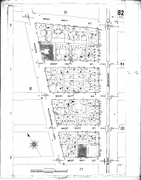
Fire Insurance Maps $180 (with Database Report only)
Fire Insurance Maps were first published in the mid-1800s. These maps show details of urban and industrial areas such as roads, building footprints, building construction details, location of storage tanks, the building use at the time the map was prepared and the names of the building occupants. From these maps you can note the location of wells, raw material storage locations and the locations of storage tanks containing chemicals and petroleum products.
ERIS has a collection of close to 1 million historic Fire Insurance Maps covering many areas of the United States. Fire Insurance Maps may be purchased along with a database report or as part of a package.
Topographic Maps $95 per set of maps
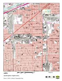
ERIS’ topographical maps were first published in the late 1800s and now cover the entire United States. Topographic maps show natural features such as wooded areas, lakes, rivers, wetlands and topographic relief. Cities and towns are depicted along with individual structures in rural areas and man-made structures such as roads, railroad tracks, dams and bridges. Certain land disturbance activities such as quarries, mines and ditches, which may have environmental research importance are often shown.
- ERIS provides digital copies of current and historical 7.5- and 15-minute USGS topographic maps for the entire United States.
- All topographic maps are in color and include a scale bar and the year created/updated.
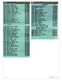
City Directories $95 for one street $115 for two streets $25 for each additional street
City directories are valuable historical data sources for identifying past occupants of buildings over long periods of time. ERIS has a research team of experts located at multiple research facilities throughout the country. As available, ERIS will provide digital images for your property or address range.
Research Parameters
- City directory covers your site at approximate five year intervals.
- Specify which additional street you would like ERIS to research or we will select the street for you based on the information you provide.
- An ERIS representative will contact you if we discover conflicting or incomplete information regarding your site location and the streets to be researched.
- For many older cities, city directory coverage can date back to the early 1900s.
- Custom city directories can also be searched. Please contact us for more details.

And now, there's SmartCD:
The SmartCD is the most comprehensive and intuitive city directory report in the industry.
ERIS has developed a proprietary methodology to better select adjoining properties based on the E1527-21 Standard's guidance. It allows the professionals at ERIS to use their knowledge of historical and regional nuances to provide an ASTM-compliant CD search with no extra work for you. It alleviates any guess work and results in a high quality, more accurate, and ASTM-compliant product – with fewer reworks.
Here's the process:
- Outline the boundary of your subject property when placing the order.
- Our team will pull relevant adjoining property addresses based on your subject property boundaries.
- Our researchers utilize their access to parcel information, historical maps, imagery, and other sources as needed. This helps not only to identify adjacent addresses but also street name changes, address renumbering, historic streets, etc.
- Should you have a larger property or complex site that requires more extensive research, our team will reach out and provide a complimentary consultation on options for you to evaluate.
2-5 business day turnaround time (more complex sites may require additional time)
For more information contact your Regional Account Manager, email us at [email protected], or live chat with us.
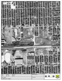
Historical Aerials $95 per set
Historical Aerials depict the history of land use over time. They are also used to determine where to drill and sample during Phase II projects. ERIS has an impressive and continually growing collection of high quality Historical Aerials, and accesses additional available sources to retrieve images as required. ERIS provides these images as a single purchase or as part of a package of environmental and historical information.
Highlights of Historical Aerial Photos:
- Most of the aerials have a scale of 1” = 500’.
- Each aerial photograph can show an area up to 5000’ x 7500’ or approximately 860 acres in size, dependent on the shape of the property. Larger sites or irregularly shaped sites may require more aerial photographs at an additional charge.
- ERIS will provide 5 to 12 historical aerial photographs of different years typically ranging from the 1930s or 1940s to the near present.
- ERIS offers several options for delivery, including: standard pdf, jpeg files, and GeoTiffs; and of course, all are accessible through ERIS Xplorer.
- Historical Aerials are offered a la carte and in ERIS’ multi-product packages.
NEW – Upgrade to Aerial Imaging for Large Custom Areas and Linear Projects
The upgrade allows multiple high-resolution images for large custom areas and linear projects to be viewed seamlessly in the ERIS Xplorer application.
- Integrate high-res aerial images into Xplorer to enable more depth and precision when reviewing projects.
- Overlay images effortlessly and use the Opacity and Transition tools to assess environmental changes and risks with accuracy regardless of site size.
- Generate robust PDF reports containing both summaries and detailed imagery for large-scale projects.
- Benefit from ERIS’ end-to-end solution integration whether in the office or on-site across ERIS Mobile, Xplorer, the Figure Creator Tool, and SCRIVA, our report authoring platform.
Explore this impactful new technology on your next large scale project.
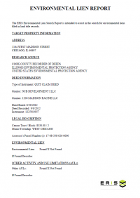
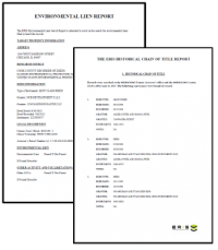
ASTM E1527-21 Compliant Environmental Lien Search Report - Ownership back to 1980 $375 per search
Environmental Lien is defined as: A charge, security, or encumbrance upon title to a property to secure the payment of a cost, damage, debt, obligation, or duty arising out of response actions cleanup, or other remediation of hazardous substances or petroleum products upon a property, including (but not limited to) liens imposed pursuant to CERCLA 42 USC 9607(1) and similar state or local laws.
To create this ASTM E1527-21 Compliant Environmental Lien Search Report, a network of professional, trained researchers, following established procedures, uses client supplied property information to:
- Search for parcel information and/or legal description;
- Search for ownership information back to 1980;
- Research official land title documents recorded at jurisdictional agencies such as recorder’s office, registries of deed, county clerks’ offices, etc.;
- Access a copy of the deed;
- Search for environmental encumbering instrument(s) associated with the deed;
- Thorough review of CC&Rs
- Provide a copy of any environmental encumbrance(s) based upon a review of key words in the instrument(s) (title, parties involved and description); and
- Provide a copy of the deed or cite documents reviewed.
If ordering an Environmental Lien Search Report with more than one address, parcel number, Lot/Block, legal description, etc., each will be charged as a separate search. They may not follow the same chain. If your client expects to pay for only one search, please choose one address, parcel number, Lot/Block, legal description, etc.
5-12 business day turnaround time (multiple parcel searches may require additional time)
Environmental Lien Search Report - Current Owner Only $145 per search
Environmental Lien is defined as: A charge, security, or encumbrance upon title to a property to secure the payment of a cost, damage, debt, obligation, or duty arising out of response actions cleanup, or other remediation of hazardous substances or petroleum products upon a property, including (but not limited to) liens imposed pursuant to CERCLA 42 USC 9607(1) and similar state or local laws.
To create an Environmental Lien Search Report, a network of professional, trained researchers, following established procedures, uses client supplied property information to:
- Search for parcel information and/or legal description;
- Search for CURRENT ownership information;
- Research official land title documents recorded at jurisdictional agencies such as recorder’s office, registries of deed, county clerks’ offices, etc.;
- Access a copy of the deed;
Search for environmental encumbering instrument(s) associated with the deed; - Provide a copy of any environmental encumbrance(s) based upon a review of key words in the instrument(s) (title, parties involved and description); and
- Provide a copy of the deed or cite documents reviewed.
If ordering an Environmental Lien Search Report with more than one address, parcel number, Lot/Block, legal description, etc., each will be charged as a separate search. They may not follow the same chain. If your client expects to pay for only one search, please choose one address, parcel number, Lot/Block, legal description, etc.
3-7 business day turnaround time (multiple parcel searches may require additional time)
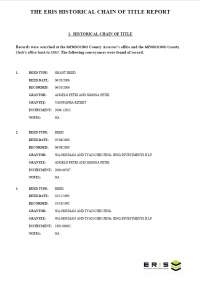
60-Year Historic Chain of Title Report $335 per parcel
A search for a property’s previous owners of a certain piece or parcel of land, typically going back to 1940, showing recorded date, grantor, grantee, and recorded instrument information. A copy of the current vesting deed can be included if requested at time of order.
If splits occur (ex: current parcel was assembled from 2 or more parcels back in the 1960s), additional costs to be approved before work continues. Time required to receive approval for additional splits is not included in turnaround time. Splits must have a common back chain. Multiple chains also occur when partial interests are conveyed to multiple parties. For example, if an owner conveys 1/20 interest to ten separate owners, then each one of those ten owners has a separate ownership chain until a single party assembles them.
If ordering a Chain of Title with more than one address, parcel number, Lot/Block, legal description, etc., each will be charged as a separate search. They may not follow the same chain. If your client expects to pay for only one search, please choose one address, parcel number, Lot/Block, legal description, etc.
3-12 business day turnaround time (multiple parcel searches may require additional time)
ASTM E1527-21 Compliant Lien & Title Bundled Property Report $550 per search
Environmental Lien Search Report back to 1980 & 60-Year Historic Chain of Title Report
Together the environmental lien search report and historic chain of title report provide the most detailed information on the history of ownership and financial status of a property.
If ordering with more than one address, parcel number, Lot/Block, legal description, etc., each will be charged as a separate search. They may not follow the same chain. If your client expects to pay for only one search, please choose one address, parcel number, Lot/Block, legal description, etc.
3-12 business day turnaround time (multiple parcel searches may require additional time)
Lien & Title Bundled Property Report $345 per search
Environmental Lien Search Report & 60-Year Historic Chain of Title Report
Together the environmental lien search report and historic chain of title report provide detailed information on the history of ownership and financial status of a property.
If ordering with more than one address, parcel number, Lot/Block, legal description, etc., each will be charged as a separate search. They may not follow the same chain. If your client expects to pay for only one search, please choose one address, parcel number, Lot/Block, legal description, etc.
3-12 business day turnaround time (multiple parcel searches may require additional time)
Updated Title Report $125 per search
The Updated Title Report fulfills the need for construction loan monitoring. The report targets the subject property to verify ownership and to check for any encumbrances, for example, mortgages, taxes, liens, or judgments. The report ensures that there are no liens recorded (for example, by the contractor for non-payment) since a loan was secured for the property. The research is conducted using the official land records associated with the subject property.
Use ERIS to secure:
- A fixed rate nationwide
- A very quick turnaround time
- Guaranteed accuracy
- Order / delivery flexibility
Turnaround time: 1 business day

ERIS XPLORER Mapping Tool Included with all database orders and packages
ERIS Xplorer is an innovative and powerful interactive tool for analyzing environmental data and historical site images showing multiple layers of data on one screen. This platform allows the user to visualize and analyze all of the environmental risk information about a study area – all in one place, with built-in tools for analysis and customization. ERIS Xplorer can be ordered as an add-on product to any environmental Database Report, Physical Setting Report (PSR) or Historical Product, including Aerial Photographs, Topographic Maps, and Fire Insurance Maps.
Features of ERIS Xplorer
- Overlay data and multiple images over current street layers and compare changes over time.
- Switch between Street, Satellite, or Terrain base layers to more effectively analyze the project property and related data.
- Accommodate Custom / Linear Reports for efficient review and analysis.
- View the transition of study area images through the decades using the Transition Tool.
- Filter data sources and view only the desired data sources on the map.
- Look up specific addresses or keywords using the Search functionality.
- Calculate the distance between 2 points or within a polygon area using the Measure Tool.
- Draw and/or add comments directly to any layer, then print to PDF for easy sharing between colleagues and clients.
- Save views with your drawings, measurements, notations and filters.
- New! Determine the direction of water flow from your subject property using the Water Flow Direction Tool.
- Centralize Reports and Historical Products for the study area all in one place – no need to leave the application to download reports.
For more information, visit: https://www.erisinfo.com/eris-xplorer/
Vapor Screening Package
$40 with an E1 to E6 Report Package or $150 as a Vapor Screening Package (inc DB Report and Xplorer)
ERIS has created a new tool dedicated specifically to assessing the risks associated with vapor encroachment.
ERIS' Vapor Screening Tool helps identify a Vapor Encroachment Condition (VEC) as part of a Phase I Assessment (complying with ASTM E2600-15). It applies approximate minimum search distances surrounding the target property to identify the default Area of Concern (AOC) and assists in identifying potential Chemicals of Concern (COC) and Petroleum Hydrocarbon COCs. The tool allows fine-tuning of the AOC based on the user's expertise and knowledge of the site by adjusting groundwater flow direction and search distances for up-, cross-, and down-gradient quadrants. It helps determine whether or not a VEC exists by posing a list of preset questions about natural features, preferential pathways, soil characteristics, and physical barriers.
Key Features:
- Is efficiently integrated within ERIS Xplorer – analyze, interpret and create your report all in one place
- Is easy to learn and use through a central menu of functionalities
- Intuitively displays groundwater direction on the map but contains adjustment options
- Displays all data and information in a centralized table for easy review and report creation
- Provides powerful search capabilities of data sources
- Can include multiple layers in the review and analysis (e.g. Topo, FIM, PSR)
- Includes a ‘Vapor Checklist’ that poses questions to help determine whether a VEC exists; and allows commentary for inclusion in the Vapor Report
- Provides ‘Preview’ or ‘Detail’ Vapor Report options
- Organizes the Report in a very easy-to-read format including: an Executive Summary, and vapor encroachment details for each site selected for inclusion.
The Vapor Screening Tool can be added to any E1 to E6 Report Package for an additional $40 on the Order Form. Or, it is available as the 'Vapor Screening Package' which includes a Database Report and ERIS Xplorer for $150.

ERIS MOBILE Field App Download for free and access your ERIS orders in the app
ERIS Mobile is the first-ever fully integrated mobile app for on-site environmental due diligence.
- View data and images for your project on an interactive map – from your device
- See your project details just like you would in the office
- Upload new information like photos and notes, and tag their exact location
- Complete on-site checklists
- Easily access all the information you collected in the field to use in Xplorer, Figure Creator and now, Scriva!

FIGURE CREATOR Access Figure Creator through ERIS Xplorer
- Prepare, crop, annotate, title, customize and save/generate the images you want.
- Zero in on the important features of your site that your client will want to see. Highlight just what you want to show. Create the perfect Figure 1.
- Customize any figure by adding data layers, boundaries, drawings/symbols and annotations – whatever you need to make the right things stand out. Add titles and comments to your photos.
- Seamlessly integrate the photos captured on-site via ERIS Mobile (or upload your own), so they become a key part of your appendix document.
- You can use any image from the project as a figure, such as FIMs, Aerials and Topos.
- Xplorer has several built-in templates that you can brand with your company logo and then incorporate your customized figures and photo logs.

PINPOINT Available through Xplorer on a company-approved basis
Within Xplorer, Pinpoint allows users to modify records within a database report quickly and efficiently.
- Move the location of records,
- Plot ‘unplottables’,
- Exclude records from the report, and
- Generate (revised) Database Reports – new reports will be emailed with a downloadable link for review.
This feature is only available on a company-approved basis. Clients who would like to use Pinpoint must have their senior management’s approval to ‘opt-in’ – to have it activated for all subsequent reports delivered through their Xplorer platform.
ERIS DIRECT: On-Demand Information for Environmental Risk Searches
Does your company need regular access to environmental site information? Do you want answers immediately? ERIS DIRECT is for you.
Real Time Environmental Risk Information
ERIS DIRECT is an online subscription service that provides real-time environmental risk information for properties throughout the United States and Canada. Environmental risk searches can be performed from your own computer, on specific addresses and/or company names, with environmental information delivered to you immediately.
ERIS DIRECT lets you quickly assess property condition and environmental perils for:
- Environmental audits
- Site selection
- Financing
- Underwriting
- Financial reporting
- Legal due diligence
- Mergers & Acquisitions
- Divestitures
ERIS DIRECT features include the ability to:
- Search for data in both the US and Canada
- Save environmental search criteria and results
- Combine the results from many searches on one report
- Drill down to the information you need with Country, State/Prov and Data Source filters
- Easily review records in your searches and choose to include/exclude them from your report
- Choose the file format of the final output
- View the projects your staff are working on and see the status
- Make projects 'private' to ensure confidentiality or 'public' to facilitate collaboration across individuals and offices
Let ERIS DIRECT make your environmental risk searches easier — and faster. For more information, visit: www.erisinfo.com/eris-direct

Scriva
Scriva is the latest technology innovation from ERIS, completing a comprehensive array of tools, including ERIS Xplorer, ERIS Mobile, Figure Creator, the Vapor Screening Tool (US), and ERIS Direct.
Scriva is a state-of-the-art online report-writing platform that offers:
- Flexible, form-built document templates
- Comprehensive integration with all ERIS data and tools
- Unlimited users and templates
- Easy-to-use, customizable interface and project management dashboard
For more information about everything Scriva can do to make report writing easier, visit scriva.com, or contact Dan McAuley, Sales Manager, at [email protected]
THE ERIS REPORT
ERIS database reports provide current and historical environmental information for any property in North America in a concise and comprehensive manner. Key federal, state or provincial and private sector databases are researched to identify and pinpoint environmental concerns associated with a particular property. ERIS reports are used to aid in the identification of possible environmental risks for commercial, industrial and residential sites. ERIS reports meet the CSA standards in Canada and the ASTM standards in the United States. Each report contains:
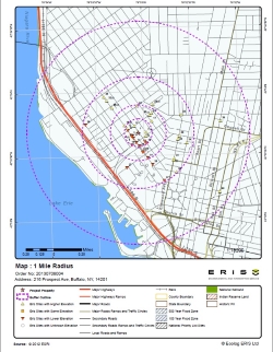
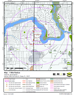
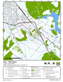
- A map that displays the subject property at the center of a predefined radius and all adjacent properties that lay there within.
- A current aerial that displays the subject property and surrounding areas.
- An executive summary that indicates site information such as site name, address, elevation, latitude/longitude.
- A report summary that shows databases that were researched and the number of points that lie within preset search distance for each database. (Clicking on the database abbreviation will take you to the database descriptions section).
- A site report summary that lists sites within the project property and surrounding properties and indicates distance and elevation difference; sites are sorted by distance and direction. (Clicking on the ‘map key’ will send you to the relevant map; clicking on the ‘page number’ will take you to that site’s detail in the detail report).
- A detail report of all the records found within the radius that surrounds the site; these records can be matched to locations on the site diagram by way of the ‘map keys’.
- An appendix that lists definitions and database descriptions.
NEED-TO-KNOW FACTS About the ERIS Report
Functions within the database report are best optimized with Adobe 11
- Interactive links are highlighted in blue
- Adobe Bookmarks are located on the top left-hand side of the report; click the second icon to reveal the green table of contents; click on a section to access the details within, as well as the blue interactive links