ERIS' infoHUB: News, updates, podcasts,
blogs and videos - ALL IN ONE PLACE.

The ERIS Database Report

Whether you are doing a Phase I, Phase II, remediation, loan or insurance assessment, or legal due diligence, ERIS is your fast, accurate and affordable resource for assessing environmental risk. ERIS can provide environmental database reports that meet ASTM/AAI standards, as well as the historical products of your choice to fulfill your requirements.

ERIS database reports provide current and historical environmental information for any property in North America in a concise and comprehensive manner. Key federal, state or provincial and private sector databases are researched to identify and pinpoint environmental concerns associated with a particular property.

Each report contains:

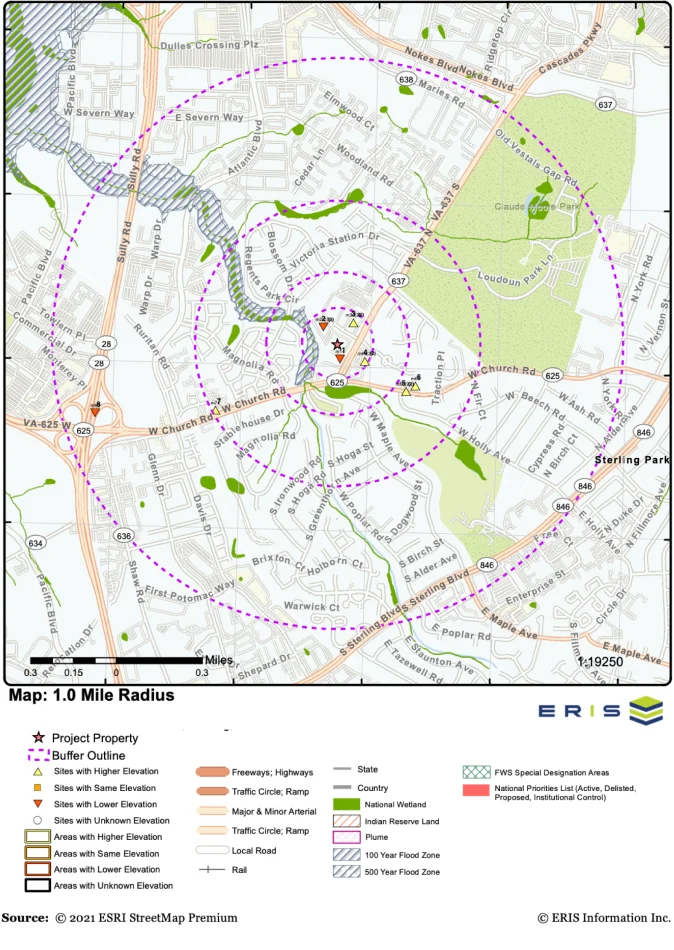
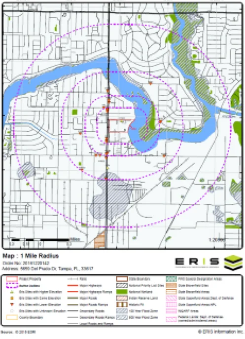
  1. A map that displays the subject property at the center of a predefined radius and all adjacent properties that lay there within.
  2. A current aerial that displays the subject property and surrounding areas.
  3. An executive summary that indicates site information such as site name, address, elevation, latitude/longitude.
  4. A report summary that shows databases that were researched and the number of points that lie within preset search distance for each database. (Clicking on the database abbreviation will take you to the database descriptions section).
  5. A site report summary that lists sites within the project property and surrounding properties and indicates distance and elevation difference; sites are sorted by distance and direction. (Clicking on the ‘map key’ will send you to the relevant map; clicking on the ‘page number’ will take you to that site’s detail in the detail report).
  6. A detail report of all the records found within the radius that surrounds the site; these records can be matched to locations on the site diagram by way of the ‘map keys’.
  7. An appendix that lists definitions and database descriptions.

Reliable and constantly updated data

At ERIS we work hand in hand with hundreds of institutions to provide updated, reliable and easy-to-use data.

Get in touch with us

Click here to request a demo.  One of our Regional Account Managers will contact you immediately.

ERIS covers the United States!

ERIS reports are used to aid in the identification of possible environmental risks for commercial, industrial and residential sites. ERIS reports meet the CSA standards in Canada and the ASTM standards in the United States.

  • 1-3 day turnaround time
  • Multiple Radius Database Report meeting ASTM standards
  • ‘Express Preview Report’ is available within minutes of ordering
  • Accurate and detailed environmental risk reports
  • Precise property locations for more accurate risk assessments
  • Overview and detailed street maps with point data
  • Interactive display of precise information through links between summary and detailed information
  • Bookmarking between pages for ease of use
  • Scrubbed and cleaned data, with low orphan sites
  • Easy-to-read format

Custom Reports & Packages

At Eris we are focused on providing a service that meets the needs of our clients, therefore, in addition to our robust reports, we provide customized reports and tailored packages.

Custom Radius Reports

Custom radius reports allow you to conduct Information for Environmental Site Assessments in a set radius around a site locus, or to define your own custom site boundaries.

Our proprietary software combines environmental site data from several different databases including federal, state, and local governing environmental records to produce a thorough and detailed report. The report highlights environmental risk features such as the storage of hazardous materials to sites with environmental liability or contamination issues.

Custom Radius Environmental Report Features

  • Ideal for large or irregularly shaped sites
  • Report Analyst-verified, delivered in 2 business days
  • Choose search area, radius, multiple radii, and specific databases required (or search all databases)

Need a quote for a unique or large site search? On the online Order Form, select “Quote – Custom Build Your Own Report” on the Select Report page. You can submit your custom boundaries by creating a specific polygon, or by uploading a site map.

Custom Linear Reports

Custom linear or corridor environmental reports are ideal for projects that follow a line such as railroads, pipelines, roads, and tracks – where search results can be tailored to a linear property boundary.

Custom linear reports can be ordered by simply providing us with the coordinates, a map, or even a site illustration by fax or by email. Our linear mapping professionals will create a custom environmental test report with the required defined distance around your linear area or corridor.

Custom Linear Environmental Report Features

  • Choose search area and the databases required (or search all)
  • Ideal for linear sites
  • Report Analyst-verified, delivered in 2 business days

Need a quote for a unique or large site search? On the online Order Form, select “Quote – Custom Build Your Own Report” on the Select Report page. You can submit your custom boundaries by creating a specific polygon, or by uploading a site map.

Environmental Database Report Packages

E1 $95 / $135; E2 $220; E3 $275; E4 $300; E5 $410; E6 $605

ERIS introduces environmental database report product packages…

The foundation of each package is an ERIS Database Report for your site of choice.

The E1 includes a corresponding set of Fire Insurance Maps from our comprehensive collection of Historical products.

The E2 package adds a choice of one of three additional Historical products: Aerial Photos, Topographic Maps, or a City Directory (one street). The new Physical Setting Report (PSR) will be included in every E2 to E6 package. (Prices quoted reflect ‘not finding’ or ‘finding’ FIMs associated with the subject property).

The E3 adds a choice of two of three additional Historical products to your environmental database report. Choose from: Aerial Photos, Topographic Maps, or a City Directory (one street).

The E4 is an ERIS Database Report, plus FIMs, Aerial Photos, Topographic Maps and a City Directory (two streets).

The E5 package adds an Environmental Lien Search to your Database Report and Historical information.

The E6 adds a Chain of Title to your Database Report and Historical information.

The offering of these new product packages will not impact any current packages or volume pricing agreements previously established with ERIS.

Want to learn more about or Database Reports?

Connect with us to get more information about our Custom Database Reports or any other of our products and services for environmental due diligence.

ASTM/AAI-Standard Reports

All reports include customized and interactive maps of various scales, showing target properties and surrounding areas, as well as detailed records found within defined radii. All records are linked to the final detailed report. Key databases include:

  • CERCLIS List
  • CERLCIS NFRAP Site List
  • Delisted NPL Site List
  • ERNS List
  • Federal Institutional and Engineering Control Registries
  • FIND/FRS Site List
  • MLTS Sites
  • NPL Site List
  • RCRA CORRACTS Facilities
  • RCRA Generators List
  • RCRA TSD Facilities
  • Superfund Enterprise Management System (SEMS)
  • Spill/Incident Reports
  • State Brownfield Sites
  • State Hazardous Waste Sites Identified for Investigation or Remediation
  • State Institutional and Engineering Control Registries
  • State Solid Waste Disposal Sites
  • State/Tribal Leaking Storage Tanks
  • State/Tribal Registered Storage Tanks
  • State/Tribal Voluntary Cleanup Sites
  • TRI List
  • TSCA Sites

End-to-end solutions

It’s all about efficiency. Our integrated services platform allows you to save time, increase productivity and work with a set of integrated tools. Our Databases Reports naturally integrate with Eris Xplorer to analyze information through layers and generate reports in one place. Eris Direct provides real-time environmental risk information for properties in real time.

ERIS Xplorer is an innovative and powerful interactive tool for analyzing environmental data and historical site images showing multiple layers of data on one screen. This platform allows the user to visualize and analyze all of the environmental risk information about a study area – all in one place, with built-in tools for analysis and customization. ERIS Xplorer can be ordered as an add-on product to any environmental Database Report, Physical Setting Report (PSR) or Historical Product, including Aerial Photographs, Topographic Maps, and Fire Insurance Maps.

Features of ERIS Xplorer

– Overlay data and multiple images over current street layers and compare changes over time.
– Switch between Street, Satellite, or Terrain base layers to more effectively analyze the project property and related data.
– Accommodate Custom / Linear Reports for efficient review and analysis.
– View the transition of study area images through the decades using the Transition Tool.
– Filter data sources and view only the desired data sources on the map.
– Look up specific addresses or keywords using the Search functionality.
– Calculate the distance between 2 points or within a polygon area using the Measure Tool.
– Draw and/or add comments directly to any layer, then print to PDF for easy sharing between colleagues and clients.
– Save views with your drawings, measurements, notations and filters.
– Centralize Reports and Historical Products for the study area all in one place – no need to leave the application to download reports.

Does your company need regular access to environmental site information? Do you want answers immediately? ERIS DIRECT is for you.

Real Time Environmental Risk Information

ERIS DIRECT is an online subscription service that provides real-time environmental risk information for properties throughout the United States and Canada. Environmental risk searches can be performed from your own computer, on specific addresses and/or company names, with environmental information delivered to you immediately.

ERIS DIRECT lets you quickly assess property condition and environmental perils for:

– Environmental audits
– Site selection
– Financing
– Underwriting
– Financial reporting
– Legal due diligence
– Mergers & Acquisitions
– Divestitures

ERIS DIRECT features include the ability to:

– Search for data in both the US and Canada
– Save environmental search criteria and results
– Combine the results from many searches on one report
– Drill down to the information you need with Country, State/Prov and Data Source filters
– Easily review records in your searches and choose to include/exclude them from your report
– Choose the file format of the final output
– View the projects your staff are working on and see the status
– Make projects ‘private’ to ensure confidentiality or ‘public’ to facilitate collaboration across individuals and offices

Let ERIS DIRECT make your environmental risk searches easier — and faster.

Want A Quick Look at Other ERIS Tools?

ERIS has the most innovative and powerful due diligence tools in the industry. Get to know our tools  >>